What was known. What cannot be forgotten.
 CLICK FOR LARGER IMAGE
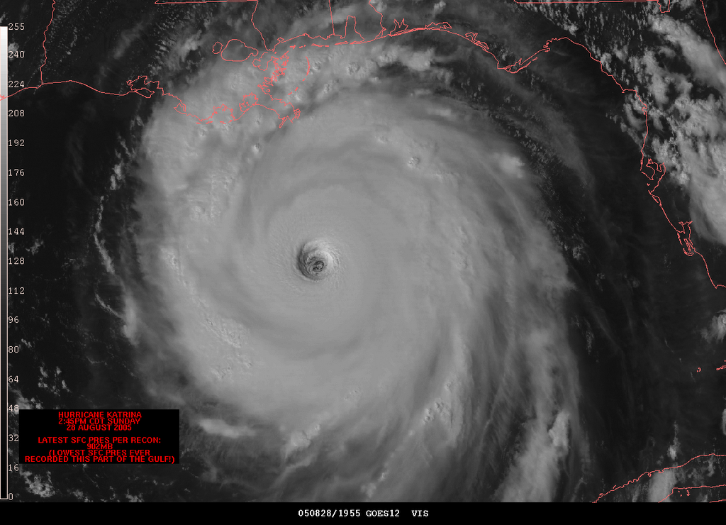 Katrina - Sunday, August 28, 2005
For those of you who have not seen Spike Lee's HBO documentary: "When the Levees Broke: A Requeim in Four Acts", I highly recommend it. Forget color, class, whatever, you will be moved and sometimes disturbed by the stories and images of the massive devastation to lives, property and culture caused by Hurricane Katrina. Lee (who is never seen) has produced an unforgettable account of a horrendous failure of government at all levels.
Most unsettling, is the disclosure of while thousands in the middle of the disaster suffered without food, water or medical care, President Bush was playing "air guitar" at a California speech on the war in Iraq, Secretary of State Condoleeza Rice was shopping for shoes, catching a Broadway play and playing tennis with Monica Seles and Vice-President Dick Cheney was fly-fishing.
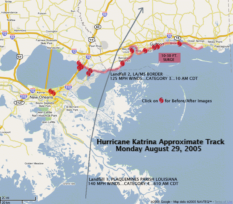
As the one year anniversary of Hurricane Katrina's devastating blow to New Orleans and the Gulf Coast approaches, I thought I would post the National Hurricane Center's advisory on Katrina as of Friday, August 26, 2005 at 11 p.m.
To all in the federal government who have said time after time: "We didn't know...," well guess what: YOU DID:
ZCZC MIATCDAT2 ALL
TTAA00 KNHC DDHHMM
HURRICANE KATRINA DISCUSSION NUMBER 15
NWS TPC/NATIONAL HURRICANE CENTER MIAMI FL
11 PM EDT FRI AUG 26 2005
...STUBBORN KATRINA CONTINUES TOWARD THE WEST-SOUTHWEST...EXPECTED
TO BECOME AN INTENSE HURRICANE IN THE CENTRAL GULF OF MEXICO...
KATRINA IS FORECAST TO MOVE DIRECTLY OVER THE WARM LOOP CURRENT OF THE GULF OF MEXICO...WHICH IS LIKE ADDING HIGH OCTANE FUEL TO THE FIRE. THEREFORE...THE OFFICIAL FORECAST BRINGS KATRINA TO 115 KNOTS (135 m.p.h.)...OR A CATEGORY FOUR ON THE SAFFIR-SIMPSON HURRICANE SCALE. THE GFDL IS MORE AGGRESSIVE AND CALLS FOR 124 KNOTS (145 m.p.h.) AND 922 MB. THE FS SUPERENSEMBLE IS EVEN MORE AGGRESSIVE BRINGING KATRINA TO 131 KNOTS (150 m.ph.)*
THE OFFICIAL FORECAST BRINGS THE CORE OF THE INTENSE HURRICANE OVER THE NORTH CENTRAL GULF OF MEXICO IN 48 HOURS OR SO. IT IS WORTH NOTING THAT THE GUIDANCE SPREAD HAS DECREASED AND MOST OF THE RELIABLE NUMERICAL MODEL TRACKS ARE NOW CLUSTERED BETWEEN THE EASTERN COAST OF LOUISIANA AND THE COAST OF MISSISSIPPI. THIS CLUSTERING INCREASES THE CONFIDENCE IN THE FORECAST.
FORECASTER AVILA
*It should be noted here that Katrina at one point over ran the model predictions on Sunday, August 28th with a pressure of 902 mb and sustained winds of 185 m.p.h. with gusts to 215 m.p.h.
posted by Matthew Cortez at 8/23/2006 01:10:00 PM
![]()
![]()


<< Home